Vittoria State Forest
Vittoria State Forest is located halfway between Bathurst and Orange and is home to one of the premier forest recreation sites in the state. It has both pine plantations and native forest and is home to a variety of native fauna.
- Vittoria State Forest Map [271 KB PDF]
Recreational Areas
Macquarie Woods
![]()
![]()
![]()
![]()
![]()
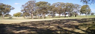
This relatively unknown treasure offers picnicking and camping areas, walking tracks and a lookout with extensive views of the Macquarie Valley.
Macquarie Woods is situated on the Mitchell Highway about halfway between Bathurst and Orange. Macquarie Woods covers an area of 600 hectares and was established in 1988 as a demonstration forest.
It displays exotic conifer planted forests and has an area of native woodland which once dominated the landscape. This is made up of yellow box, Blakely’s red gum, red stringybark and apple box and other eucalypts in an expanse of native grass.
A large picnic area situated in the middle of the Forest with a camping area and information shelter completes the site.
Closures and notices
- 1 Dec 2023 - 30 Dec 2024Replanting operations near Macquarie Woods
Maps
Staying Safe
- Important information when visiting state forests
- Call '000' in a bushfire emergency (www.rfs.nsw.gov.au)
- Total Fire Ban and Current Fire Danger Map (www.rfs.nsw.gov.au)
- Signs in State Forests
- Solid Fuel Fire Bans
Useful information
Authorised hunting
Some State forests are declared for authorised hunting. Find out more about authorised hunting in State forests, including licensing and applying for permits.
Pesticide use This area is designated as ‘high public usage’ under Forestry Corporation of NSW’s Pesticide Use Notification Plan [PDF 3.83 MB].
Visit sustainably
Find out how to minimise the impact of your visit.