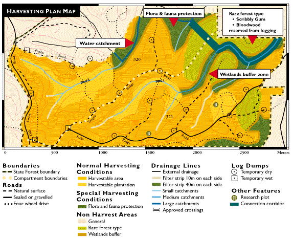
Here is an example of a harvesting plan map, showing harvestable and non-harvestable areas and other features:
Notes on the plan
Boundaries
State forest boundary - marks the area of land managed by State Forests.
Compartment boundaries - smaller areas within State forests that are managed for specific purposes.
These two compartments have been planned for harvesting timber whilst protecting environmental issues such as flora and fauna protection, water quality and soil erosion.
Roads
Natural surface - minor roads used for removing timber from dumps.
Sealed or gravelled - major roads used for removing timber from dumps. These roads consist of a layer of either gravel or bitumen on top of the natural surface for longer wear.
Four wheel drive - very minor roads usually only accessible by four wheel drive vehicles
Normal harvesting conditions
Harvestable area - the area where normal harvesting operations will be carried out. Here the trees are generally larger and suitable for sawing.
Harvestable plantation - the area where normal plantation harvesting will be carried out. These trees were planted for harvesting and have now grown to a suitable size.
Special harvesting conditions
Flora and fauna protection - in these areas there is a limit on what can be harvested. This may be to protect species of plants and animals, or to leave more trees for fauna protection.
Non harvest areas
General - areas outside the compartment(s) to be harvested.
Rare forest type - areas left to protect rare species.
Wetlands buffer - areas left to protect wetland communities.
Drainage Lines
Drainage line - an area where water drains to, such as streams, creeks and rivers.
External drainage - drainage lines outside of the compartment to be harvested.
Filter strip 10 m on each side - areas of vegetation reserved to protect water quality by filtering out soil before it reaches the drainage line.
Filter strip 40 m each side - areas of vegetation reserved to protect water quality by filtering out soil before it reaches the drainage line.
Catchments - areas which collect rain water and channel it into drainage lines.
Small catchments - drainage lines which occur in catchments less than 40 ha in area.
Medium catchments - drainage lines occurring in catchments between 40 ha to 100 ha in area.
Large catchments - drainage lines which occur in catchments greater than 100 ha in area.
Approved crossings - points at which machines are allowed to cross the drainage line.
Log dumps
Dry dump - temporary sites where logs await collection and are only accessible by log trucks during dry weather conditions.
Wet dump - temporary sites where logs await collection and are accessible by log trucks during all weather conditions.
Other features
Research plot - a site within a compartment used for research purposes over a period of time. Research may include growth rates and logging methods.
Connection corridor - areas of unlogged forest connecting one reserve to another to enable animals to move between reserves.